

Media Releases
Business for Impact:
Eco-index evolves into a Charitable Company
4 December 2025
Eco-index Ltd is proud to announce its evolution into a charitable company, marking a bold new chapter in its mission to deliver lasting, nature-positive impact across Aotearoa New Zealand.
Founded in 2019 as a mission-led research programme, then converted in 2024 to a purpose-driven business, Eco-index has now adopted a new hybrid legal structure that ensures all profits are reinvested into charitable mahi. This transformation affirms Eco-index’s commitment to nurturing taonga tuku iho - the treasures handed down to us, especially our environment and communities.
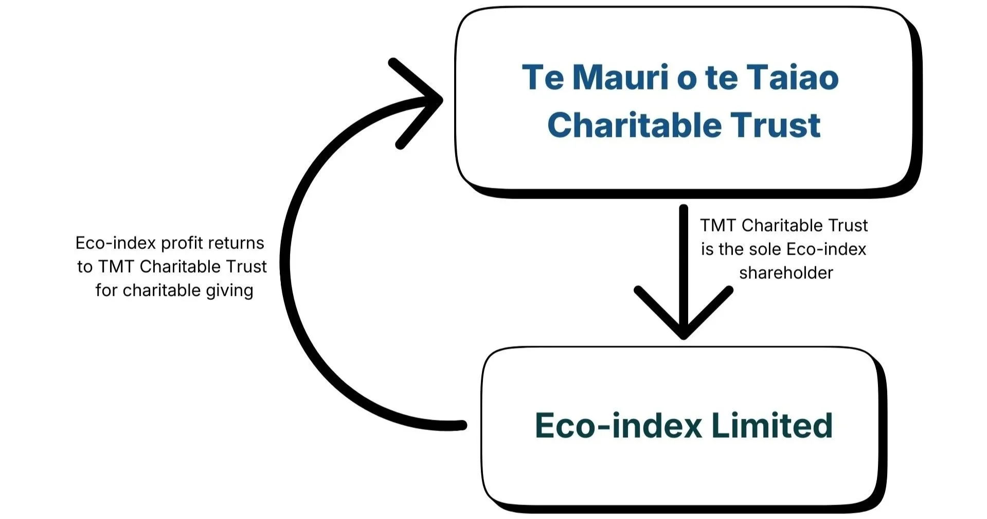
Under the new structure, Eco-index is wholly owned by the Te Mauri o te Taiao Charitable Trust. All profits generated by Eco-index now flow directly to the Trust to support nature-positive action nationwide. The organisation’s vision remains clear: to weave knowledge and people to revolutionise investment for Te Taiao.
Dr Kiri Joy Wallace, Eco-index Director, says the transition brings the organisation’s intentions to life in a powerful new way.
“We're putting our money where our mouth is! I’m thrilled to see Eco-index formally transition to a legal structure suited to its roots and values, that is, for maximum funding flow to positive environmental impact." says Dr Wallace.
“Most companies must generate profits for individual shareholders, meaning all decisions are ultimately made to increase the wealth of individuals. I'm proud to be a director of a different sort of company - where all profits increase the wealth of society and the environment as a whole.”
The company will continue to use best business practice to generate profits from their top-shelf products and services, including AI-driven tools and remote sensing tech. But the new hybrid structure ensures every dollar they receive aligns with their vision and values.
Te Mauri o te Taiao Trustee Jan Hania is pleased to support Eco-index in combining the tools of business with the purpose of charity.
“This transition recognises that enduring environmental and social wellbeing comes from aligning our structures with our values. By placing Eco-index within a charitable framework, we are strengthening the company’s ability to serve nature and communities at scale, while honouring the interconnectedness of people, place and purpose.” says Hania.
Looking ahead, Eco-index and Te Mauri o te Taiao Charitable Trust are ready and eager for their next chapter together.
“We are very excited about this change and hope it gives funders, partners and clients even more confidence in us,” Dr Wallace says.
“Our journey from research into business, and now into a deeper manifestation of purpose-driven business, has shown us that meaningful change for Te Taiao requires a cross-section of many skillsets. The challenges we’ve navigated have strengthened our relationships, perspectives and capability so we are best-placed to power nature-positive mahi across the motu.”
ENDS
Dr Kiri Joy Wallace - Eco-index Director

Jan Hania - Te Mauri o te Taiao Trustee
FAQs
What does this mean for funders, partners and clients?
Eco-index remains committed to delivering practical solutions using data and digital tools to support nature-positive decision-making.
How does this work?
Eco-index Limited used to be owned by the founding team of individuals, who were all shareholders. They have donated their shares so the company is now entirely owned by a charitable trust as the sole shareholder. Any profits must flow to this trust, where they are used to support charitable activities and growth of Eco-index. The charitable trust and charitable company are accountable to Charities Services New Zealand, and their regular reporting requirements.
Why make this change?
Eco-index has always existed to create impact for nature and people, not increase the wealth of individuals. This shift to a hybrid structure locks that purpose into a legal and financial foundation - strengthening reputation by ensuring profit and purpose are permanently aligned.
What is a charitable company?
A charitable company is a standard limited liability company whose sole shareholder is a registered Charitable Trust under the Charities Act 2005. Unlike a not-for-profit, the company should generate profit, but they are not distributed for private gain. All profits must serve charitable purposes.
Acknowledgements
Eco-index and Te Mauri o te Taiao Charitable Trust warmly acknowledge the many people who have shared their journey, including current and past members of the Eco-index whānau and their network of advisors, supporters, funders, partners and clients.
Researchers estimate cost of reconstructing native habitat
16 December 2024
The cost of reconstructing enough native habitat for nature to thrive across New Zealand has been estimated by the Eco-index research programme and published in an update to its online Ecosystem Reconstruction Map.
Ecosystem reconstruction involves recreating native habitat in areas where it has been completely removed. This often occurs in retired pasture, in urban parks or along waterways and usually involves planting native trees and shrubs alongside weed and pest control.
The first version of the Eco-index Ecosystem Reconstruction Map was launched in November 2023 to share information about the need to not only look after existing ecosystems but reconstruct missing ones too.
“Biodiversity in Aotearoa is in decline,” says Eco-index Co-Director Dr Kiri Joy Wallace from the University of Waikato. “We want to understand where we can most effectively invest in reversing this trend.”
Last month, for version 2.0 of the map, the team put a price tag on the ecosystem reconstruction required for each catchment to reach at least 15% cover of their local ecosystem types. These estimates include the cost of purchasing native plants, fencing and three years’ worth of non-native plant control, when the native plantings are most vulnerable to being smothered.
“This broad-scale costing is based on information we’ve collected from across the country for ecosystem reconstruction of different native ecosystem types. It is intended as a guide to highlight the current funding gap for biodiversity in Aotearoa,” Dr Wallace says.
She says she hopes that the addition of costings to their public map – which for most catchments is a multi-billion-dollar amount – will also help people realise that ecosystem reconstruction is expensive, so it is important to value and protect what ecosystem cover they already have.
The timing of releasing the new costings is poignant too, Dr Wallace says, coming as the Department of Conservation turns to private and philanthropic donations to fill conservation funding gaps amid government budget cuts.
“Funding shortfalls for nature are not only an issue in Aotearoa New Zealand,” Dr Wallace says, referring to a 2020 report led by The Nature Conservancy which identified a global biodiversity finance gap of between US $598 and 824 billion per year.
“The cost estimate we have made available is helpful for raising awareness, but it isn’t the whole story. Some ecosystem reconstruction methods may be more cost effective than our estimates, such as those that can make the most of natural regeneration, while it is imperative that the costs to protect and restore existing native ecosystems are considered.”
The Ecosystem Reconstruction Map also shows users where reconstructing native ecosystems is the highest priority, what kind of ecosystems are appropriate where and how many hectares need to be reconstructed to reach the 15% cover goal.
A grant from Biome Trust – an international philanthropic organisation focused on supporting environmental projects – helped Eco-index to launch version 2.0 of the map.
Matthew Monahan, Co-Steward of Biome Trust says, “We are pleased to support Eco-index to provide cutting-edge intelligence for land planning and biodiversity investment. Their work to bring data and technical expertise together is important for many large-scale environmental projects.”
As well as adding cost information to the map, the Biome Trust grant has helped Eco-index to develop and share two digital products that organisations can use to harness the reconstruction map’s data within their own systems. These have so far been provided for free to Te Arawa Lakes Trust and Taranaki Mounga Project.
Eco-index was initiated through the collaborative Biological Heritage National Science Challenge, but with funding from the National Science Challenges having come to an end earlier this year, it now exists as a purpose-driven limited company associated with a charitable trust.
The charitable grant from Biome Trust has been one way that Eco-index and its products have continued to evolve and be provided free of charge to the public and community groups.
“Because our research is taking off and people are picking up the outputs and taking an interest in it, we're trying to stay together as a team to keep doing this kind of research and support this platform,” Dr Wallace says.
“We’re lucky we have some good philanthropists in the country who are interested in funding the development of these kinds of technologies – we were really grateful to get this grant from Biome Trust.”
Alongside Dr Wallace, who is an ecologist, the Eco-index team includes data scientists, an environmental economist, an impact analyst and sustainability experts.
“Together we’re weaving data into these tools that people can use, to hopefully help biodiversity and counter some of the loss.”
Dr Wallace says she finds this applied research, which takes data to the world in an easy-access way, stokes her fire.
“It seems like a lot of academic pursuit and investment never leaves the ivory tower to make the world better. I’ve found that a bit frustrating in the past and love this aspect of taking data to the world in this applied, easy-access way to hopefully make a difference.”
Estimated costings for catchment-scale ecosystem reconstruction reflect the funding gap for biodiversity in New Zealand.
New 3D mapping tool launched to assist nature investment decisions
1st October 2024
Waitaha / Canterbury is the first region in Aotearoa New Zealand to get a new online 3D map showing anyone who wants to invest in nature where they can get the best bang for their buck.
Launched today, Navigator X for Waitaha / Canterbury is a mapping tool that helps people decide where to focus their ecosystem reconstruction efforts. Ecosystem reconstruction is a specific kind of ecological restoration where native ecosystems are reconstructed from scratch. Navigator X was created by the Eco-index research programme to improve access to environmental information.
Co-Director of Eco-index, Dr Kiri Joy Wallace (University of Waikato) says “We want to help people who are interested in bringing local nature back to their landscapes. Cantabrians can now access region-wide information to help pinpoint places where ecosystem reconstruction will have the best return on investment.”
Navigator X allows users to explore a 3D landscape with different coloured layers draped across the riverbanks, plains and slopes of Waitaha / Canterbury. Eco-index Data Scientists created the map by weaving the best available and trusted national environmental datasets with economic and ecological know-how.
The coloured layers provide information about how “optimal” each area is for reconstructing native ecosystems. It allows users to consider a range of prioritisation options that represent their own reasons for undertaking ecosystem reconstruction. The prioritisation options include improving land stability, creating riparian benefits and supporting threatened environments.
This new mapping tool is especially helpful for groups wanting to collaborate across large landscapes. Wairewa Rūnanga Executive representative, Ana Gray (Kāti Irakehu, Ngāi Tahu) says "We see value in this map for supporting both rūnanga and catchment groups to get restoration work done in the right places. Greater benefits can be achieved for te taiao, including people, when we work collaboratively".
Miria Goodwin, member of the Ōpāwaho Heathcote River Network says "The Ōpāwaho Heathcote River Network is working hard alongside many others to restore health to the ecosystems and catchments of the Ōpāwaho Heathcote River and Port Hills - this 3D science-based map will help groups like ours confirm they are working in the right places and, when used alongside local ground-truthing and strong community and landowner partnerships, will likely be useful for funding applications, prioritisation processes, and interactions with others working in Canterbury".
Navigator X is helpful because many of the diverse native forests, dunelands and wetlands that once cloaked the Waitaha / Canterbury landscape are missing. Reconstructing them will support biodiversity such as native birds, bats, reptiles, plants, fungi and microorganisms. Native ecosystem reconstruction will also improve local ecosystem services such as filtration and retention of rainwater to reduce floods, erosion control, and mitigation of natural hazards such as flooding, fire and landslides.
Eco-index Co-Director Dr John Reid (Ngāti Pikiao, Tainui) says “Navigator X does not provide the whole picture for ecosystem reconstruction, but does add something new to the toolbox for decision-makers in large landscapes. We hope Navigator X for Waitaha / Canterbury will make prioritisation of reconstruction locations easier and more cost effective”.
Navigator X does not provide any landowner, local authority or private information.

Screenshot of Navigator X for Waitaha / Canterbury showing ecosystem reconstruction information. The brighter the area, the better the potential return for your biodiversity efforts. Explore Navigator X at www.eco-index.nz
Eco-index biodiversity digital tool bringing new level of smarts to Taranaki restoration efforts
25th June 2024
A digital tool that guides native habitat restoration is helping inform a landscape restoration project in Taranaki to make bigger gains.
Eco-index, a research programme established by New Zealand’s Biological Heritage National Science Challenge, has developed a science-based tool for working out the best places to target restoration efforts, such as native plantings.
Eco-index recently delivered their “Reconstruction Heat Map” to the collaborative Taranaki Mounga Project to support their restoration decision-making. The tool uses GIS mapping layers to work out the best locations to reconstruct native ecosystems where they no longer exist.
“The Reconstruction Heat Map helps people to identify the best “bang-for-buck” places to reconstruct native ecosystems from scratch,” says Dr Kiri Joy Wallace, Eco-index Co-Director. “We’ve designed our tools to help land managers maximise the chance of improving their local biodiversity while effectively using their precious time and resources”.
Taranaki Mounga Project, a collaboration between DOC, iwi, funders and community groups is restoring Taranaki Maunga and the national park, Te Papa-Kura-o-Taranaki, covering 34,000 hectares. In the past 8 years goats have been eliminated, kiwi reintroduced and species like whio/blue duck are starting to thrive again.
Sera Gibson, Taranaki Mounga Poutohu Matua Taurua/Co-Director says the tool is being used in restoration planning to help consider how the project might evolve. “It brings the ecology and science part of the puzzle together and puts it in a really accessible place along with our deep local knowledge, contextualising where we could get the most value for the taiao.”
Taranaki Mounga Co-director Sean Zieltjes adds that one of the big lessons learned is that restoration doesn’t stop at park boundaries and to aim bigger, given what’s already been achieved with the project.
“We’re using the heat map tool as an input – it adds rigour to the conversation, if connectivity between the maunga and the moana is to be achieved here’s where effort could be prioritised to ensure ecological integrity.”
With NZ’s Biological Heritage National Science Challenge wrapping up on June 30th, Eco-index’s interdisciplinary team is branching out on their own, continuing to offer information that benefits biodiversity. ‘

Taranaki Mounga Project kaimahi. Credit: Taranaki Mounga Project.
New map shows biodiversity priorities in every catchment
14th November 2023

Eco-index Ecosystem Restoration Map showing the expected natural cover of native ecosystems (L) and restoration priorities (R) in a section of the North Island of Aotearoa New Zealand.
A new interactive map, launched today, will allow iwi, community groups, businesses, government and land managers to better understand the current biodiversity of Aotearoa New Zealand by sharing information on every ecosystem in every catchment of the country.
“Our aim is to help our nation restore native biodiversity. So as a first step, we’ve built a map that allows people to explore what their local biodiversity landscape would look like without human activities and where the areas of restoration priority are,” said Dr John Reid (Ngāti Pikiao, Tainui), co-lead of Eco-index.
“In science it is known that the game changes for biodiversity if we can safeguard at least 15% of the expected natural range of each native ecosystem. So our initiative made this idea into a long-term goal. In some areas, reaching 15% requires complete reconstruction of native ecosystems through ecological restoration efforts like tree planting and non-native species removal. In areas where 15% native land cover already exists, protecting those existing ecosystems is key,” said Dr Kiri Joy Wallace, co-lead of Eco-index.
In many areas, Aotearoa New Zealand’s native biodiversity is dramatically lower than the safe lower limit needed for the ecological processes we depend upon. We need native ecosystems like forests, and wetlands to produce valuable services like reduced erosion, flooding, carbon emissions, air, soil and water pollution, non-native species spread, and also to provide for people’s physical and mental wellbeing.
“Native ecosystems once cloaked Aotearoa New Zealand. Forests, herb fields, wetlands, sand dunes and many more ecosystems were woven together with diverse and flourishing communities of plants, animals, invertebrates, and fungi,” said Dr Wallace.
“Human-driven replacement of these ecosystems with modified landscapes means that native ecosystems now exist as a patchwork of fragments which together are much less than their expected natural range, especially in lowland areas,” said Dr Wallace.
Large tracts and small patches of native ecosystems can together support more native species than either can separately, the key is to have at least 15% land cover in total. Scientific observations of a range of ecosystems and their constituent species indicate that once the area of an ecosystem drops below 10-20% of its expected natural range, the number of species it can support declines suddenly.
“Land managers, decision-makers, community environmentalists, and policy-makers have overwhelmingly good intentions, but they still have lots of questions that we hope our new map will begin to answer,” said Dr Reid.
Eco-index today launched a free interactive map to provide information on the expected natural range of plants and ecosystems within each local catchment and the restoration priority areas where local biodiversity is most at risk.
“At a national level, there are challenges around biodiversity data collection, access, and sharing,” said Sam Rowland, Programme Manager - Nature, Systems Change at the Sustainable Business Network and co-chair of the Eastern Whio Link. “This map is a good start at fixing those issues and we’re excited to utilise this information for biodiversity strategies and planning.”
The Ecosystem Restoration Map was designed for land management decision-makers in Aotearoa New Zealand and was developed with input from iwi leaders, rural professionals, community group leaders, council representatives and industry peak bodies to help with prioritisation of restoration action in real-world scenarios.
“Te Rarawa is committed to bringing back the mauri of our whenua through our Me He Wai project. This map will add to the information we have about our rohe and support our kaitiakitanga, especially when we’re thinking about restoring local wetlands and kahikatea-pukatea-tawa forest,” said Maihi Makiha (Te Rarawa) Manu Kura for Me He Wai.
The interactive map includes targets for reaching the 15% land cover goal for each catchment (85 catchments nationally) and by ecosystem type (31 different ecosystems). These appear along with stories of biodiversity success, links to local catchment groups that people can get involved with, and other helpful map layers.
“As sheep farmers near Lake Coleridge, we are very lucky to have many pockets of old and regenerating bush still on our station. This map is going to be a fantastic tool for planning native planting on our farm and the other farms near us. We are trying to regenerate pockets of what should be growing here, so our aim is to reintroduce kahikatea and mataī at lower altitudes,” said Jo Johns of Glenthorne Station.
Jo is a NZ Merino grower, who, with her husband Chris, and another three other Gorge farmers recently started a local catchment group to protect their part of the Wilberforce and Rakaia River Valleys.
“The targets for each local ecosystem were carefully calculated by the Eco-index team. First, we looked at the ecosystem types that would likely exist without the presence of people and the area they would naturally occupy. Then we compared this to the native ecosystem cover of today, allowing us to see what was missing, and then recommend these targets for the range of ecosystem types that belong in every catchment in the country,” said Dr Wallace.
Background
Each of Aotearoa New Zealand’s more than thirty native ecosystem types include a wonderful range of native species, in combinations often unique to their area. These ecosystems are different from the far north to the south, and from mountain tops to coastlines. Many species under extinction risk or currently becoming threatened need restoration of specific, entire ecosystems to recover. For example, a coastal area could be planted in harakeke (flax), but it is even better to restore the rare coastal grassland that belongs there and not many other places.
The Eco-index map supports the National Policy Statement for Indigenous Biodiversity and Te Mana o te Taiao - Aotearoa New Zealand Biodiversity Strategy. It is designed to support organisations interested in the proposed biodiversity credit market and the international Taskforce on Nature-Related Financial Disclosures (TNFD) framework.
Eco-index was initiated by New Zealand’s Biological Heritage (BioHeritage) National Science Challenge. Eco-index is geared toward galvanizing action, aiming to drive motivation and engagement of the key land management sectors through the provision of science-based ecological restoration guidance; the Eco-index Ecosystem Restoration Map is the first of their publicly-available tools.
Dr John Reid - Earth Quotient & University of Canterbury
Dr Kiri Joy Wallace - University of Waikato
The New Zealand Merino Company
signs on to partner with Eco-index

Dr Kiri Joy Wallace
Eco-index Co-lead

Monica Schwass
NZ Merino Future Farming Manager
27th September 2022
The New Zealand Merino Company (NZM) is teaming up with the Eco-index programme to develop remote-sensing technology for quantifying native biodiversity on sheep farms.
The two parties recently signed a Memorandum of Understanding, agreeing to collaborate to improve understanding of biodiversity regeneration across NZM’s suppliers, while helping test Eco-index tools.
Eco-index is a national programme that is building new tools that will generate information to help protect, restore and connect our native ecosystems. It is part of the BioHeritage National Science Challenge.
Eco-index co-lead Dr Kiri Joy Wallace (University of Waikato) says “We’re excited that this partnership will help test our methods for improving understanding of native ecosystems on sheep farms across Aotearoa.
“With information on ecosystem type and extent we can provide guidance for land manager’s restoration efforts, including which ecosystems are most at risk and what the best bang-for-buck restoration options are.”
Dr Wallace says they will also be able to tell land managers the cost of different biodiversity-friendly actions.
The New Zealand Merino Company (NZM) owns the ZQRX platform, which is a regenerative framework that helps farmers work positively with nature. ZQRX farms cover approximately 1.8 million hectares of land in Aotearoa.
NZM future farming manager Monica Schwass says “It’s hugely exciting to have a scaleable method for quantifying biodiversity on sheep farms, and then to use this information to create a pathway for biodiversity investment on farm.”
The teams aim to ultimately utilise Artificial Intelligence to identify both passive and active ecosystem regeneration on farms.
Dr Wallace says “We’re using machine learning to scan satellite imagery and tell us how much land is regenerating back to native ecosystems. This will give us accurate information about the state of the biodiversity, which is exactly what decision-makers need.”
Schwass says “As well as supporting decisions to improve biodiversity, the tool can provide evidence to our consumers about the positive impact our wool growers are having on their land.”
Eco-index the first in New Zealand to gain international
Digital Public Good certification
4th October 2022
The Eco-index Biodiversity Dashboards have become a certified digital public good with the international Digital Public Goods Alliance – a first for Aotearoa New Zealand.
A digital public good is an open-source digital tool designed for the public good. Eco-index is a national programme that is building new tools that will generate information to help protect, restore and connect our native ecosystems. It is part of the BioHeritage National Science Challenge.
Eco-index Strategy and Artificial Intelligence Advisor Nathaniel Calhoun says “The super goal of people working in digital development is to make and give away things into the digital commons that everyone can use to solve the pressing issues of today.”
The layers of the Biodiversity Dashboards that Eco-index is developing can be used for monitoring the current state of, and changes in, biodiversity at a large scale. They also allow for the correlation of those changes with economic investments being made to improve biodiversity outcomes.
The dashboard layers will be able to be generated for regions, catchments, iwi and primary industries. The tool will allow governments, iwi, communities or research organisations to see progress in activities such as environmental restoration, and make improvements to their strategy for better biodiversity outcomes.
The Eco-index Biodiversity Dashboards’ certification places the tool as one of 139 digital public goods on the registry and the only certified good from Aotearoa.
Being certified connects the Eco-index – and Aotearoa – with large, multinational organisations who may seek to apply this tool in other countries and contexts.
“Currently, scientists from the University of Waikato and the University of Canterbury are being asked for scientific and technical advice by a major European organisation concerned with ecosystem regeneration,” says Nathaniel. “This connection is a direct result of achieving Digital Public Good status.”
The Eco-index Biodiversity Dashboards have gained credibility in the global community not only because of the tool’s scientific excellence but because of the team’s efforts to inform their work with Te Ao Māori concepts.
In many places where biodiversity monitoring is most political and most needed, there is a fraught cultural line between the Indigenous people and outside forces with an interest in conservation,” says Nathaniel.
The Eco-index team is working to raise the issue of Indigenous data sovereignty and is pleased to find the international community engaging on these topics as well.
Nathaniel Calhoun
Eco-index AI & Strategy Advisor

